onX Hunt: Offline Hunting Maps
Hot Novels


Install Tips
Mobile safety & integrity report for the latest package. We provide verifiable checksums and a timestamped scan summary. Latest package onX Hunt: Offline Hunting Maps 25.44.0 scanned by multiple engines; no threats detectedas of Tue, 28 Jul 2026 12:08:59 GMT.
After downloading, use a system or third-party checksum tool to calculate the SHA256 and ensure it matches the value provided on this page (case-sensitive, without spaces).
Each engine uses different signature databases and heuristics, so results may vary slightly. We provide a timestamp and checksum to allow you to independently verify the package.
onX Hunt: Offline Hunting Maps Review
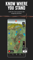
Navigate your next hunt with topo maps, GPS navigation, species distribution, hunting units, and more. Know where you stand by viewing private and public land ownership data and landowner names. Maximize your hunting experience with onX Hunt.
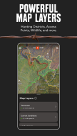
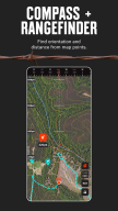
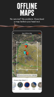
View topo maps to plan your hunt or toggle between satellite and hybrid Basemaps. Open 3D maps, mark crucial locations with Waypoints, and measure the distance to the nearest access point with Lines. Save Offline Maps to go as far from the grid as you want. Hunt by species and toggle Map Layers for deer, elk, turkeys, or waterfowl.
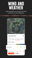
Map property lines to hunt with confidence and find new opportunities nationwide. Utilize offline navigation by downloading detailed maps with your Markups. Monitor weather conditions, wildlife distribution, and data on trees, crops or soil by switching between custom Map Layers. View Trail Cameras for recent activity and Wind Calendars for stand locations.
Access GPS navigation directly on your phone or instantly drop a Waypoint from your wrist using Wear OS. Explore a hunting app that enhances your efficiency in the field by giving you the recon tools you need.
Discover new access, find more game, and hunt smarter with onX Hunt.
onX Hunt Features:
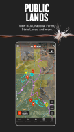
▶ Public & Private Land Boundaries
• Check property lines and land boundary maps with landowner names (U.S. only)*
• View Hunting Units or GMU to plan ahead. Study county and state land hunting maps
• Navigate public land with Forest Service or Bureau of Land Management (BLM) maps
• Observe state lines and locate Wildlife Management Areas, Timber Lands, and more
* Private land ownership maps may not be available for all counties (U.S. only)
▶ Offline Maps & Custom Layers
• Use 2D or 3D maps to understand the terrain and visualize your hunt
• Topo maps, satellite or hybrid Basemaps. Take advantage of easy-to-read visuals
• Save Offline Maps with your Layers, custom Markups, and Waypoints
• 7-day weather forecast. Study conditions or view wildlife and tree distribution
▶ Hunt Planner & Tracker
• Connect Moultrie trail cameras to see images in real time & receive key insights
• Measure distance between two points with the Line Distance Tools
• Map routes, mark locations, view Optimal Wind and save access points
• GPS navigation app. Log your hunt, monitor duration, distance, and speed
• Scout from the comfort of your home with our online Desktop Maps
▶ Free Trial
Start a free trial when you install the App and select your state of choice.
▶ Premium Membership:
Access all of the features listed above in a single state or Canada. Hunt more game with land ownership maps, custom map layers, offline navigation, and more!
▶ Premium+ Membership:
Get all of the benefits of our Premium Membership but for two states, or one state plus Canada.
▶ Elite Nationwide Membership:
The best tool for the best hunters. With a nationwide Membership, you get a complete, purpose-built solution for dedicated hunters and the game they pursue, including:
• Proprietary maps for all 50 states and Canada
• Advanced Tools: TerrainX 3D Viewer, Recent Imagery, Route Builder
• In-dash navigation with Android Auto
• Exclusive pro deals and expert resources
• Draw Odds and Application Tools
▶ Government Information & Data Sources
onXmaps, Inc. does not represent any government or political entity, though you may find various links to public information within our services. For more info on any government information found within the services, click on the associated .gov link.
• https://data.fs.usda.gov/geodata/
• https://gbp-blm-egis.hub.arcgis.com/
• https://www.arcgis.com/home/group.html?id=00f2977287f74c79aad558708e3b6649#overview
▶ Terms of Use: https://www.onxmaps.com/tou
▶ Privacy Policy: https://www.onxmaps.com/privacy-policy
▶ Feedback: Have a problem or want to request new features? Please contact us at support@onxmaps.com
Additional information
Screenshots


Reviews
Recommend Article


Similar Apps
Get live scores, NFL scores today & football results with real-time updates.
Stream Formula 1® Live and on-demand
Golf Scorecard, Shot & Handicap Tracker, Range Finder, and AI Swing Analyzer
Team and Group communication
CCTV Camera Recorder App, BVR Background Video Recording with Lock Phone Screen.
Keep score, find disc golf courses, track your stats, measure throws, and more!