Podorozhka
Hot Novels


Install Tips
Mobile safety & integrity report for the latest package. We provide verifiable checksums and a timestamped scan summary. Latest package Podorozhka 4.26.0(260) scanned by multiple engines; no threats detectedas of Tue, 28 Jul 2026 12:10:03 GMT.
After downloading, use a system or third-party checksum tool to calculate the SHA256 and ensure it matches the value provided on this page (case-sensitive, without spaces).
Each engine uses different signature databases and heuristics, so results may vary slightly. We provide a timestamp and checksum to allow you to independently verify the package.
Podorozhka Review
Podorozhka is a simple and convenient tool that helps you plan your metro trip in Saint Petersburg and instantly check your Podorozhnik transport card balance using your smartphone’s NFC feature.
Easily manage your daily travel and prepare for your metro rides in advance — all in one lightweight app.
Key Features
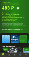
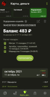
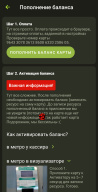
Instant Podorozhnik Card Balance Check
Quickly check your Podorozhnik card balance by tapping it to your phone.
Works instantly with NFC-enabled and compatible Android devices.
No need to visit ticket machines or service kiosks — know your balance anytime, anywhere.
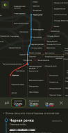
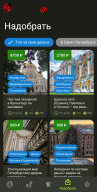
Plan Your Metro Trip
Access the Saint Petersburg metro map directly within the app.
Plan optimal metro routes before your journey to save time and avoid confusion.
Ideal for both daily commuters and visitors to the city.
Requirements
NFC-enabled Android device required for card balance checking.
Ensure NFC is turned on in your device settings before scanning your Podorozhnik card.
Why Use Podorozhka
Fast and reliable metro route planning.
Accurate balance checking with NFC technology.
Simple, intuitive interface for quick navigation.
Perfect companion for Saint Petersburg metro travelers.
With Podorozhka APK, you can always stay informed and ready — plan your trip, check your balance, and enjoy a smoother travel experience across the Saint Petersburg metro network.
Changelog
Jan 19, 2024
Plan your metro trip using metro map and check your card's balance in advance. Download the latest version of Podorozhka: metro map + pass 4.26.0 to enjoy new features and updates immediately!
Internal improvements
FAQ
Additional information
Screenshots

Reviews
Recommend Article


Similar Apps
Display GPS location on a map using GPS Coordinates app for Android.
Buy your tickets, search for itineraries and follow the traffic information
Hear Caller ID and notifications aloud while driving, working out, or relaxing.
Airport parking, with airport shuttle (TPS shuttle), reservations, and Spot Club
Request rides quickly with Lyft, anytime, anywhere.
Gas Station & Fuel Rewards Points